Vision

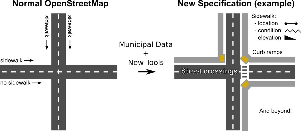
Sidewalks provide a primary mode of travel that supports nearly all other travel options, leisure, recreation and community activities. This project seeks to make pedestrian ways, particularly sidewalks, first class members of an open data transportation network. The OpenStreetMap (OSM) project has made available extensive, user-contributed open data on transportation networks, providing the basis for many use cases and downstream activities, including rich analytics, travel route optimization, city planning, and disaster relief. Some footways have been annotated in OSM as independent routes. However, sidewalks in the built environment have generally been treated an addendum to streets.

As a result, sidewalks in OSM have spotty coverage and an unintuitive implementation. The current standard makes user contribution difficult and fails to serve many use cases, including the needs of people with limited mobility. This project proposes to jumpstart an effort to generate an OSM-based pedestrian network with global coverage.

OpenSidewalks Diagram

Objectives

  1. Draft an OSM standard for sidewalk representation and annotation consistent with standards for other pedestrian ways
  2. Put standard into practice on a private server for trial purposes prior to submission to the OSM community
  3. Manipulate municipal sidewalk data for demonstrative purposes
  4. Provide tools to automate the incorporation of public data into the OSM standard
  5. Provide tools with inclusive, intuitive interfaces for individual contribution of sidewalk data into the OSM standard

Timeline

There are two phases to the proposed DSSG work, each of which represents a significant contribution to different stakeholder groups.

PHASE I

The DSSG team worked to adapt an OSM data layer for use with sidewalk data, the group learned what nuances in the sidewalk data impact both standardized incorporation into OSM as well as ability to route. The group drafted an OSM standard for sidewalk representation and annotation with the following objectives:

  1. Extension of the current OSM standard, focusing on innovation for pedestrian routing applications with particular attention to accessibility
  2. Compatibility with existing sidewalk data, as well as extensibility for manually added and municipally collected sidewalk data
  3. Data sharing - Facilitate importing and exporting of data through simple, clear standards for annotation
  4. Extended sidewalk data, in order to enable:
    1. Routing - Facilitate pedestrian routing with support for classes of different accessibility features
    2. Basic visual map display - Support meaningful visual interpretations of pedestrian data (ideally with existing rendering software) by capturing key features in a standardized format
    3. Annotation of significant accessibility features:
      1. Terrain - Support annotation of incline grade that is compatible with OSM standards and accessibility needs
      2. Junction views - Support detailed annotation of intersections and crossings of pedestrian ways
      3. 3D objects, landmarks, points of interest - Support detailed annotations of objects in and features of pedestrian ways

PHASE II

The DSSG team design and implement prototype tools to import sidewalk data from existing datasets and manual annotation. These tools must support recognition of potential conflicts between newly imported and existing pedestrian OSM data in order to facilitate supervised integration of new sidewalk information. Specifically, the DSSG team built and adapted:

  1. Tools to facilitate users’ annotation of pedestrian ways, supporting:
    1. GPS-based mapping of pedestrian ways with endpoints indicated by users
    2. Labeling of significant pedestrian features (as described above)
  2. Tools to facilitate importing of pedestrian way data from public sources, including:
    1. Supporting bulk import of pedestrian data from standard formats (e.g., geojson, shapefiles, KML)
    2. Testing (of both the data specification and tool) by incorporating data from multiple municipalities into a private OSM layer

PHASE III (current)

Enable rapid scaling. This effort is focused on 3 key areas:

  1. Incentivize/employ local ambassadors for hosting mapathons
  2. OpenStreetMap-focused software engineers to complete a mapathon-and-education-focused toolkit for streamlined data collection, and community management infrastructure in place for orchestrating global efforts (collaboration with Feet First).
  3. Build strategic plan for “NextTen”* urban centers for expansion (subgroup led by Urban@UW), establish regional local voting memberships inclusive of expanded region’s local groups. "NextTen" urban centers include:
    1. New York City
    2. Washington, DC
    3. Boston
    4. Chicago
    5. San Francisco Bay
    6. Portland
    7. Pittsburgh
    8. Denver
    9. Philadelphia
    10. Atlanta

*Urban centers identified based on rankings in Foot Traffic Ahead, a walkability study published by Christopher B. Leinberger & Michael Rodriguez of The George Washington University School of Business

Future

Looking forward our goal is to expand OpenSidewalks providing accessible pedestrian routing solutions worldwide. Our planned path forward is outlined as follows:

  1. Completion of a testing set of ten urban centers around the world, with accompanying alpha version of a global-scale accessible pedestrian trip planning service.
  2. Completion of any revisions needed to account for results of initial mapping efforts:
    • Changes to the data model (updated at key testing locations), mapathon and educational mapping efforts, the pedestrian trip planner, and update software toolkits to reflect these changes.
    • With the data model/toolkits largely finalized, the project scales up (again) to include all cities and interested areas.
    • Automated sidewalk segmentation effort is finalized and deployed.
  3. Global-scale pedestrian analytics and trip planning as data becomes more complete. Most cities will have had their pedestrian network mapped. New software tools will be written with a focus on data maintenance and revision.
  4. As cities move to sustaining the data model, efforts to add new data will focus on (likely rural) areas that have a much lower people-to-roads/sidewalks/paths ratio than urban areas.
  5. Project completion: all deliverables finalized, most edits to sidewalk-focused features in cities will be revisions.

Terminology

We attempt to use terminology consistent with OSM’s language for pedestrian ways. We use “sidewalks” to delineate pedestrian-accessible footways associated with larger streets. Our standard applies to the broader category of “pedestrian ways” or a “pedestrian network,” which includes all paths, sidewalks, crossings, and other routes that are accessible by foot or with the use of assistive devices, regardless of accessibility by other forms of transportation.

Team

OpenSidewalks is led by the Taskar Center for Accessible Technology (TCAT) at the University of Washington, whose mission is to develop and deploy technologies that improve quality of life for people with disabilities.

Urban@UW, a partnering University of Washington coalition, has fostered long-term partnerships with key leaders and stakeholders to prioritize urgent urban challenges and support equitable urban growth.

We are also thrilled to partner with Feet First, the only pedestrian advocacy group operating in Washington State, promoting community engagement in pedestrian ways and supporting projects like Safe Routes to School.

The University of Washington's eScience Institute provided an opportunity for the OpenSidewalks project to develop as a part of their Data Science for Social Good program that took place in the summer of 2016. Through this program, an interdisciplinary team of project leads, data scientists, and student fellows spent 10 weeks pushing the project forward.

Project Leads

Nick Bolten
Anat Caspi


Data Scientists

Vaughn Iverson (primary)
Bryna Hazelton (secondary)


DSSG Student Fellows

Tom Disley
Meg Drouhard
Jess Hamilton
Kaicheng Tan

Taskar Center for Accessible Technology Logo
Urban@UW Logo feetfirst logo Urban@UW Logo