Overview
Teaching: 15 min Exercises: 30 minQuestions
What are the various ways that we can represent geospatial information?
How does a database store spatial information?
Objectives
Learn the difference between geographic and projected coordinate systems
Explore why understanding the coordinate reference frame matters when carrying out basic geospatial analysis
Become familiar with some of the geospatial toolkits within PostGIS
Calculating distances
- our last research question was:
What is the most common crime within 5 km of my house?
- To answer this we’ll need to understand something about mapping, and how databases encode spatial information.
- Note that the database currently has latitude and longitude information, for example:
SELECT latitude, longitude
FROM seattlecrimeincidents
LIMIT 5;
| Latitude | Longitude |
|---|---|
| 47.6158384 | -122.3181689 |
| 47.60087709 | -122.3312162 |
| 47.59582098 | -122.3175691 |
| 47.6140991 | -122.3174884 |
| 47.63148825 | -122.3125079 |
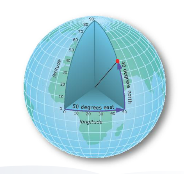
- latitude and longitude are components of the Geographic reference frame and are the most common ways to encode geospatial information:
What is the straight line distance between the first two points in the table above?
DISCUSSION: Calculating distances in geographic coordinates
- is it possible for us to calculate straight line distances directly from latitude and longitude data?
- Why or why not?
- Are distances between lines of latitude always the same? Between lines of longitude?
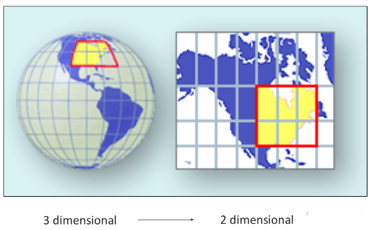
Map Projections
- often we need to convert a 3D earth to a 2D plane
- this is necessary for accurate calculation of distances, bearing and area calculations
- in a general sense, projection is similar to shining a light through a transparent sphere and tracing the lines of lat/long
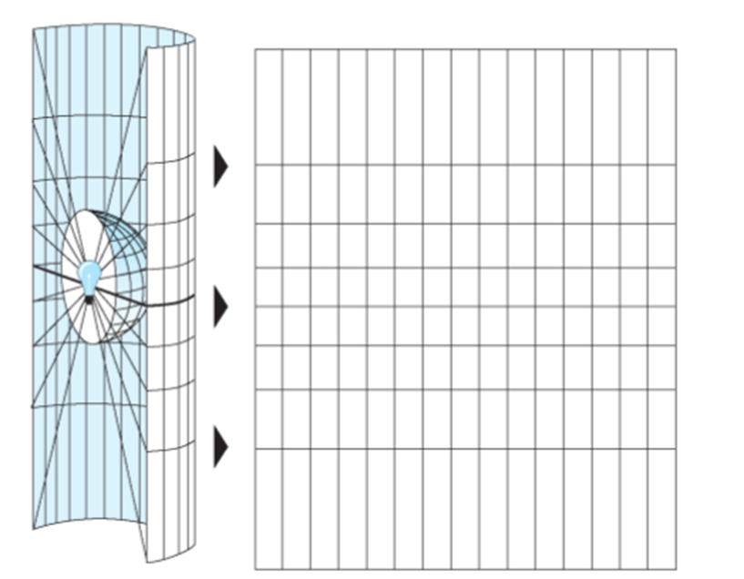
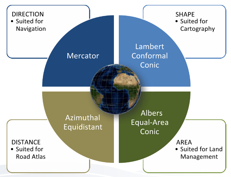
- there are numerous different map projections, each optimized for different types of applications and calculations
Encoding of geospatial information
How does the database currently encode the latitude and longitude information?
- We can determine this by querying the database for information on the type of column variables:
SELECT column_name, data_type
FROM information_schema.columns
WHERE table_name = 'seattlecrimeincidents' AND (column_name = 'Latitude' OR column_name = 'Longitude');
| column_name | data_type |
|---|---|
| Longitude | double precision |
| Latitude | double precision |
- we see from this query that the spatial data format is double precision
PostGIS: a geospatial database extension
- many databases, have extensions that allow for encoding of geospatial information
- in the case of PostgreSQL this extension is called PostGIS
- our sample database already has the PostGIS extension installed and enabled
Database Geometries
- encoding of geospatial information occurs within a new geometry column:
ALTER TABLE seattlecrimeincidents ADD COLUMN geom geometry(Point, 4326);
- this adds an empty geometry column:
| Point | Latitude | Longitude | geom |
|---|---|---|---|
| 1 | 47.6158384 | -112.3181689 | |
| 2 | 47.60087709 | -112.3312162 |
Spatial Reference System Identifier (SRID)
4326is the SRID for the geographic (latitude/longitude) coordinate system- SRIDs are a convenient way to keep track of the hundreds of different reference systems
- another label for these is
EPSGand you can access the list of codes here
UPDATE seattlecrimeincidents SET geom = ST_setSRID(ST_MakePoint(longitude, latitude), 4326);
| Point | Latitude | Longitude | geom |
|---|---|---|---|
| 1 | 47.6158384 | -112.3181689 | 0101000020E6100000AD0617E15C945EC07CCFEDCAD3CE4740 |
| 2 | 47.60087709 | -112.3312162 | 0101000020E6100000F2B96EA532955EC09A3B5D8AE9CC4740 |
- the actual content of the geom column is a binary string read by PostGIS
- Now that the database has geometric encoding, we can use a wide range of geospatial functions
Geospatial functions
- often we receive geospatial information in various different projections and/or coordinate systems
- PostGIS provides mechanisms for us to transform between different systems
- here we will transform our geometries into a projected coordinate system so that we can calculate distances
- We add a new column that has a projected geometry
- in this case we will use ‘Universal Transverse Mercator Zone 10 North’, which has a SRID of 3717:
ALTER TABLE seattlecrimeincidents ADD COLUMN geom_utm geometry(Point, 3717); -
Now we carry out the transformation
UPDATE seattlecrimeincidents SET geom_utm = ST_Transform(geom,3717);- note that all PostGIS functions begin with
STwhich means “Spatial Tool”
- note that all PostGIS functions begin with
-
Now we can recalculate our distance using a built-in PostGIS distance function:
 SELECT ST_Distance(a.geom_utm,b.geom_utm)
 FROM seattlecrimeincidents AS a, seattlecrimeincidents AS b
 WHERE a.gid=1 AND b.gid=2;
Result
| st_distance |
|---|
| 1930.45436426609 |
Compare results
How does this result compare to the distance we calculated from the latitude/longitude data alone? What explains the difference?
What is the most common crime within 1 km of my house?
- Find the coordinates of your house (or some other feature in the Seattle region). HINT: you can use google maps to find the latitude and longitude of any map location
- Build the SQL query. You will need to nest 4 different functions to do this:
ST_MakePoint: to make a vector point geometry from your lat/long coordinate pairST_SetSRID: to tell the database which SRID your lat/long pair conforms toST_Transform: to transform your point geomtery to a projected coordinate system (use UTM Zone 10, ‘3717’)ST_Distance: to calculate the distance between all the geometries in the database and your single point
Key Points
All geospatial analysis requires a knowledge of reference frames and coordinate systems
Be sure to use the correct coordinate system to match your analysis, otherwise you can get unexpected results
many databases have extensions that encode geospatial information (e.g. PostGIS)
PostGIS functions provide a wide range of tools to incorporate spatial analysis into your workflow